
Travel Weather Outlook: Maps and Forecast Cues for the Next Few Days
A travel-first forecast for the days ahead
Anyone traveling over the next few days should be prepared for a mix of conditions that could disrupt schedules in some places while leaving other regions largely unaffected. The broad theme is a familiar one for domestic travel: weather-induced delays are most likely across the Eastern half of the country, while record warmth dominates the West. That contrast matters not only for what you pack, but for how you plan connections, driving windows, and time buffers around airport hubs.
This outlook focuses on what the forecast implies for real-world travel decisions: where thunderstorms could create trouble spots, where persistent showers may lead to slower commutes and occasional flight delays, and how the jet stream can influence flight times depending on whether you are traveling eastbound or westbound.
Eastern U.S.: A low pressure system shifts east on Wednesday
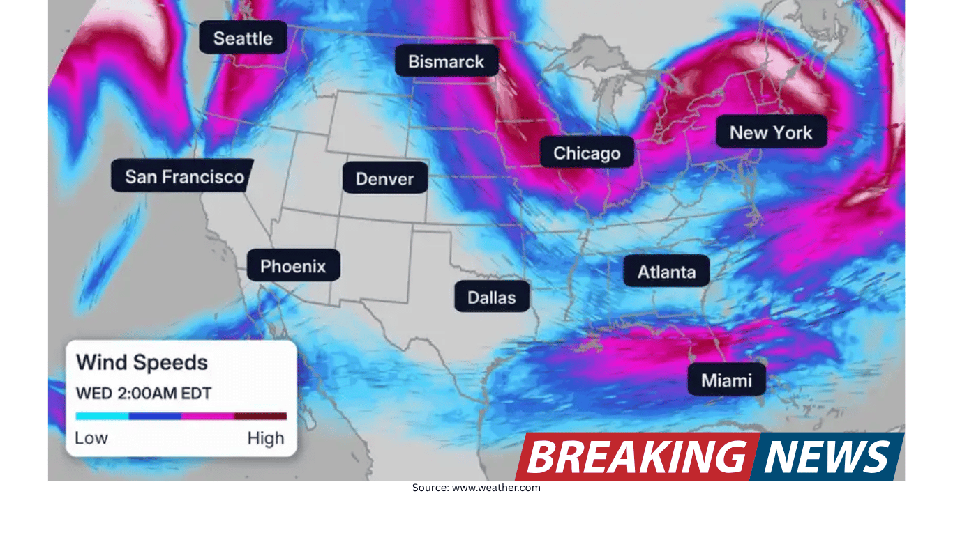
The primary travel concern in the near term is a low pressure system and its cold front moving east on Wednesday. As it shifts, it is expected to bring rain and storms from New England to the Carolinas by Wednesday night. For travelers, that timing is important: evening and nighttime arrival banks at major airports can be especially sensitive to thunderstorms and periods of heavier rain, even when impacts are not widespread.
If your itinerary includes the Northeast corridor Wednesday night, it is worth anticipating the possibility of weather-related delays. The forecast specifically highlights major hubs such as New York and Washington, D.C. as places where travelers could encounter disruptions. In practical terms, that can mean longer taxi times, ground stops, or delays that ripple through later flights and connecting itineraries.
Northeast: Showers linger Thursday and Friday
After the Wednesday night storm window, showers are expected to remain for the Northeast on Thursday and Friday. While showers do not always produce the same level of disruption as thunderstorms, persistent wet weather can still affect travel in several ways: reduced visibility, slower road conditions, and operational slowdowns at airports that can translate into occasional flight delays.
For people commuting or traveling by road, the message is straightforward: plan for wet commutes at times on Thursday and Friday. For air travelers, the key is not to assume that the most significant impacts end when the cold front passes. A showery pattern can keep conditions unsettled enough to cause intermittent delays, particularly when combined with high travel volume or tight turnaround schedules.
Florida: Continued showers and storms through Wednesday
Florida remains another region to watch. The forecast calls for showers and storms continuing through Wednesday. For vacationers and residents alike, this type of pattern can be less about a single, sweeping storm system and more about repeated rounds of downpours that briefly overwhelm roads or slow airport operations.
Travel impacts in Florida are described as potentially minor at a few airports, but even minor delays can matter if you are trying to make a connection or arrive by a specific time. For drivers, heavy downpours can quickly change road conditions, especially during commutes or when traveling between destinations. If you are planning outdoor activities as part of a trip, be prepared for interruptions and consider building flexibility into the day’s schedule.
Pacific Northwest: Scattered showers lasting through the week
On the opposite side of the country, the Pacific Northwest is expected to see scattered showers that last through the week. This is a different kind of travel challenge than the thunderstorm corridor in the East. Scattered showers can be persistent and inconvenient, influencing everything from hiking plans to city sightseeing, and they can also contribute to slower driving conditions.
Because the showers are expected to linger, visitors should think in terms of day-to-day variability rather than a single “bad weather day.” If you are planning a multi-day trip, it may help to prioritize more weather-sensitive activities during the driest windows you can find, while keeping indoor alternatives in mind for periods of heavier rain.
Record warmth dominates the West
While the Eastern half of the country deals with higher odds of rain, storms, and travel delays, the West is characterized by record warmth. For travelers, warmth itself is not typically a direct driver of delays in the way thunderstorms can be, but it can influence comfort, hydration needs, and how you plan outdoor time.
The most immediate travel takeaway is packing and planning: a trip that spans regions may require clothing for both warm conditions in the West and rain-cooled conditions in parts of the East. If you are moving between those areas, consider how quickly conditions can change from one stop to the next.
Jet stream headwinds: Why flight times differ by direction
Beyond local weather, the atmosphere’s larger-scale pattern can affect travel in a way many passengers notice without always knowing the cause: flight times can vary significantly depending on direction. In general, flights tend to travel faster eastward with the jet stream and slower westward when flying against strong headwinds within the jet stream.
For travelers, this is a useful planning detail. If you have tight connections or are trying to arrive by a certain time, the westbound leg may be more vulnerable to longer time aloft when headwinds are strong. Conversely, eastbound flights can sometimes be quicker thanks to tailwinds. The jet stream is often depicted on maps as ribbons of faster-moving air, shaded in purples, pinks, and whites.
How to use travel maps and forecast trackers effectively
Weather maps are most helpful when they are used to answer specific travel questions rather than to simply “see what the weather is doing.” The forecast discussion highlights several categories of conditions that can matter for travelers: storm systems and cold fronts, lingering showers, scattered showers, and even non-storm factors that can affect how you feel outdoors.
Below are practical ways to translate those categories into decisions you can make before and during a trip.
For Wednesday travel in the East: Watch the eastward shift of the low pressure system and its cold front. The most notable window is Wednesday night from New England to the Carolinas, when rain and storms could create trouble spots.
For Northeast travel Thursday and Friday: Keep an eye on lingering showers. Even when storms are not the main story, wet conditions can lead to occasional flight delays and slower commutes.
For Florida through Wednesday: Expect continued showers and storms. Plan for heavy downpours when driving and allow extra time for airport operations that may slow briefly in a few locations.
For the Pacific Northwest: Prepare for scattered showers through the week. This is a “bring a rain plan” pattern rather than a one-day disruption.
For cross-country flights: Consider the jet stream’s effect on flight duration. Eastbound trips often benefit from faster travel with the jet stream, while westbound trips can be slower against headwinds.
Pollen and outdoor comfort: A travel factor that is easy to overlook
Not all travel disruptions come from storms. Another factor highlighted in the forecast is seasonal pollen. Trees and grasses are in full swing in many areas, and that can affect travelers who are sensitive to pollen or who plan to spend significant time outdoors.
For pollen sufferers, the practical advice is to account for this in outdoor plans. Even if skies are not stormy, high pollen levels can influence comfort and energy levels during sightseeing, exercise, or outdoor events. If your trip includes parks, outdoor dining, or long walking days, consider how pollen might factor into your timing and activity choices.
Planning around airports and road travel
Weather does not need to be extreme to cause travel friction. The forecast points to a few common ways routine weather can complicate trips:
Thunderstorms near major hubs: When rain and storms move through heavily trafficked airspace, delays can occur even for flights that are not directly in the storm’s path.
Persistent showers: Lingering wet weather can lead to occasional delays and slower ground operations, particularly in the Northeast Thursday and Friday.
Heavy downpours on roads: Florida’s continued showers and storms through Wednesday may create brief periods of poor driving conditions, especially during commutes or on vacation routes.
Weeklong showery patterns: In the Pacific Northwest, scattered showers lasting through the week can influence day-to-day planning and comfort.
If you are building a schedule, it may help to think in terms of buffers. For example, if you are arriving in the Northeast Wednesday night, a little extra margin between landing and any fixed appointment can reduce stress if delays develop. For road trips in areas expecting downpours, allowing extra time and staying alert for rapidly changing conditions can make travel smoother.
What to watch day by day
While exact conditions can vary by location, the forecast narrative provides a clear sequence of what to monitor:
Wednesday: The low pressure system and cold front shift east. Florida continues to deal with showers and storms. The Pacific Northwest remains in a scattered-shower pattern.
Wednesday night: Rain and storms spread from New England to the Carolinas. Travelers through Northeast hubs such as New York and Washington, D.C. should be prepared for possible weather-related delays.
Thursday and Friday: Showers linger in the Northeast, with the potential for occasional flight delays and wet commutes.
Through the week: Scattered showers continue in the Pacific Northwest. Record warmth remains the dominant theme in the West.
A practical checklist for travelers
Travel forecasts are most useful when they lead to specific, low-effort actions. Based on the conditions described, here is a simple checklist that fits most trips without overcomplicating planning:
Check the timing of rain and storms if you are traveling in the Eastern U.S., especially Wednesday night.
If you are flying through major Northeast hubs midweek, consider the possibility of delays and keep connection times realistic.
For Florida travel through Wednesday, be ready for heavy downpours that can slow road travel and produce minor airport delays in a few locations.
If your destination is the Pacific Northwest, plan for scattered showers lasting through the week and keep flexible options for outdoor time.
Account for pollen if you have allergies and will be outdoors in areas where trees and grasses are in full swing.
Remember that jet stream winds can make eastbound flights faster and westbound flights slower, which can subtly affect itineraries.
Bottom line
The next few days feature a split pattern: the Eastern half of the country is the main zone for potential weather-related travel delays, while record warmth dominates the West. A low pressure system and cold front shifting east on Wednesday will bring rain and storms from New England to the Carolinas by Wednesday night, with the potential for delays at major Northeast hubs. Showers linger in the Northeast Thursday and Friday, Florida continues to see showers and storms through Wednesday, and the Pacific Northwest stays in a scattered-shower pattern through the week.
For travelers, the most effective approach is to track these regional trouble spots, build modest time buffers where storms or persistent showers are expected, and remember that jet stream headwinds can influence flight times depending on direction. Add in seasonal pollen for outdoor plans, and you have a clearer picture of what may affect both schedules and comfort during the trip.