
Why Flash Flooding Can Escalate So Quickly in Mountains, Hills and Cities
A quiet creek can become a crisis fast
Flash flooding is one of the most sudden and disruptive weather hazards because it can build rapidly—sometimes faster than people can react. In the span of minutes, water levels can rise, roads can become impassable, and familiar landscapes can turn hazardous. Meteorologist Sara Tonks describes how startling the change can be in certain environments, especially mountainous terrain.
“A creek that is 6 inches can quickly go to 10 feet deep within an hour,” Tonks says. That kind of jump is difficult to imagine until it happens, and it helps explain why flash floods are often underestimated. The danger is not only the water itself, but also the speed at which conditions shift: what looks manageable can become life-threatening before there is time to reassess.
Understanding why some areas experience faster, more intense flooding than others starts with geography, weather processes, and the practical realities of warning systems and escape routes. Mountains are a particularly strong example because multiple risk factors can overlap in the same place.
Mountains act like funnels that concentrate runoff
One major reason flash flooding hits hard in mountainous regions is the shape of the terrain. Tonks explains that mountain landscapes can function like funnels. “When you have mountain shapes, you’ve got essentially a funnel,” she says. “If there’s rain over that funnel, it all funnels down into the valley.”
This is a critical point: rainfall doesn’t need to fall directly on a creek for that creek to surge. When precipitation covers a wide area of slopes and ridgelines, gravity pulls that water downhill and concentrates it into the same drainage channels. The result is a rapid accumulation of water in valleys, streambeds, and narrow canyons—places where communities, roads, and recreation areas may also be located.
In practical terms, a small waterway can shift from a shallow flow to a powerful current because it is receiving runoff from many locations at once. That concentration effect can happen quickly, and it can happen even if the rain seems scattered or distant from where someone is standing.
Orographic lifting can increase rainfall in mountain areas
Mountains don’t just redirect water after it falls; they can also influence how much rain falls in the first place. Tonks points to a process called orographic lifting, which occurs when moist air is forced upward by terrain.
“When moist air approaches that hill, it gets forced up, it condenses and then it rains out,” she says. “There’s both a geographic shape that’s funneling the water and then also the orographic lifting is helping produce more water.”
This combination matters because it can amplify the overall impact. The landscape can help generate more precipitation, and then that same landscape can quickly route the resulting runoff into valleys. When both processes are active, the timeline from rainfall to flooding can be compressed, leaving less margin for error.
For people living in or traveling through mountain regions, this helps explain why flash flooding can feel like it “comes out of nowhere.” The rain may intensify as air rises over terrain, and the runoff may arrive in a concentrated surge, especially in narrow drainage areas.
Wildfire burn scars can reduce absorption and increase debris flow
In some locations, there is an additional factor that can worsen flooding outcomes: burn scars left behind by wildfires. Tonks highlights this risk in places such as California, where burned landscapes can change how the ground responds to rain.
“The soil in burn scars is definitely less able to absorb water very quickly,” Tonks explains. When the ground cannot take in water efficiently, more rainfall becomes surface runoff. Instead of soaking into soil, water can rush downslope.
That fast-moving runoff can also carry debris. When rainwater moves quickly over a landscape—particularly one altered by fire—it can pick up loose material and transport it downhill. This can add another layer of hazard during a flash flood event, because the threat may involve not only rising water but also debris moving with it.
Burn scars are a reminder that flash flood risk is not static. A region’s vulnerability can change after major events, and the same amount of rain may produce very different results depending on ground conditions.
Recent disasters show how quickly mountain regions can be overwhelmed
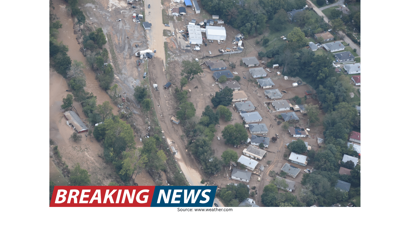
Tonks points to Hurricane Helene as an example of how mountain terrain can intensify flooding impacts. “All those mountain regions were just funneling the water into areas that could not handle that amount of water in that short a period of time,” she says.
The phrasing underscores an important reality: it is not only the presence of water, but the rate at which it arrives. Communities and infrastructure can be overwhelmed when runoff is concentrated and delivered rapidly. Even if an area has experience with heavy rain, the specific combination of terrain and rainfall can produce outcomes that exceed what local systems can manage.
In mountain settings, steep slopes and narrow valleys can accelerate how quickly water moves, and that speed can compound the danger. When flooding escalates rapidly, people may have limited time to move to safer ground, especially if they are in low-lying areas or near waterways.
Flash flood risk extends beyond mountains
While mountainous terrain is a major hotspot for rapid flooding, Tonks emphasizes that similar dynamics can affect other landscapes. Hilly terrain can also funnel water into lower areas, and urban environments can face their own version of the problem through drainage limitations.
Heavy rain upstream can create downstream impacts that are not immediately obvious. A community may experience dangerous flooding even if rainfall is heavier in another location. The key issue is that water moves, and it often moves toward the same low points—streams, channels, underpasses, and valleys—where people may live or travel.
Urban areas with poor drainage can be vulnerable because water that cannot drain efficiently may accumulate quickly. In a city, the hazard may not look like a mountain torrent, but the speed of street flooding and the disruption to transportation can still create dangerous conditions.
Detection challenges can reduce warning time
Another reason flash flooding can catch people off guard is that detection and measurement are not always straightforward, particularly in complex terrain. Tonks notes that radar may not always provide a complete picture of what has already happened on the ground.
“The radar might not be able to accurately measure the amount of rainfall that has already fallen,” she says. If rainfall estimates are uncertain, warnings can be delayed or may not reflect the full severity of conditions in a specific location.
This matters because flash floods are time-sensitive events. When water levels rise quickly, even modest delays can affect how much time people have to respond. In steep or remote terrain, the difference between early awareness and late awareness can be significant.
Communication gaps and rugged terrain can compound the danger
Even when a flood threat exists, people may not receive timely information if communication is limited. Tonks points out that in rugged terrain, cell service can be unreliable, and the landscape itself can make it harder for warnings to reach everyone who needs them.
In those circumstances, individuals may not realize the danger until they see it—at which point the situation may already be unsafe. Flash flooding is particularly unforgiving because it can turn a familiar route into a hazard quickly, and it can do so in places where there are few alternative paths.
The risk is not only the initial surge but also the isolation that can follow. When communication is disrupted, coordination becomes harder, and people may have fewer options for getting help or finding updated information.
Road washouts can eliminate escape routes
Once flooding begins, the ability to leave an area can change rapidly. Tonks warns that access to major roadways may disappear quickly. “There’s a chance that your access to major roadways could already be washed out,” she says.
She adds that this was observed during Hurricane Helene: “That's one of the things we saw a lot with Hurricane Helene. All of these mountain roadways got washed out, and people were left with no way of communicating or traveling to the outside region.”
This highlights a harsh reality of flash flood emergencies: they can become logistical crises as well as weather events. Roads and bridges are not just conveniences; they are evacuation routes, supply lines, and connections to emergency services. When they are compromised, the window for safe movement can close quickly.
What makes flash flooding so underestimated
Flash flooding is often underestimated because it can start from conditions that appear ordinary. A creek may look calm. A rainstorm may seem routine. But in the right setting—particularly where terrain concentrates runoff and atmospheric processes increase rainfall—those ordinary conditions can shift abruptly.
The unpredictability is part of the threat. Flooding can be highly localized, and the most severe impacts may occur in specific channels, valleys, or low points. People may not recognize that rainfall in one place can translate into a surge in another, especially when the landscape funnels water efficiently.
In addition, the practical limitations of detection, warning delivery, and communication can leave people with less time to respond than they expect. When combined with the possibility of road washouts, the situation can escalate from a weather concern to an immediate safety emergency.
Key takeaways for understanding local flood vulnerability
Tonks’ guidance points to a central theme: flood risk is shaped by local features, not just the forecast itself. Knowing what types of weather affect your region—and what makes your community uniquely positioned for impact—can help people better understand why flash flooding can be so fast and so dangerous.
Mountain terrain can funnel rainfall into valleys, concentrating water from a wide area into narrow channels.
Orographic lifting can increase rainfall as moist air is forced upward, condenses, and produces precipitation.
Burn scars can reduce soil absorption, sending more water downhill quickly and sometimes carrying debris.
Hills and urban drainage issues can create similar hazards, including rapid runoff and flooding in low-lying areas.
Radar and warning challenges may delay awareness if rainfall totals are difficult to measure accurately in complex terrain.
Roads can wash out quickly, cutting off travel routes and complicating communication during emergencies.
Bottom line
Flash flooding is fast, unpredictable, and often more severe in places where geography and weather processes work together to amplify rainfall and accelerate runoff. Mountain regions are especially vulnerable because terrain can both increase precipitation through orographic lifting and rapidly funnel water into valleys. In some areas, wildfire burn scars further reduce the ground’s ability to absorb water, increasing runoff and the potential for debris-laden flows.
But the risk is not limited to mountains. Hilly landscapes and cities with poor drainage can also experience dangerous flash flooding, particularly when heavy rain upstream funnels into downstream communities. Add in the possibility of radar limitations, limited cell service, and washed-out roadways, and it becomes clear why people may have little time to recognize the threat and respond safely.
As Tonks emphasizes, understanding the specific weather patterns and local features that shape your region’s vulnerability is an important step in recognizing how quickly flash flooding can develop—and why it can hit so hard.